
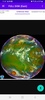
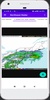


NOAA Weather Satellite Radar is a comprehensive Android app designed for real-time weather monitoring through NOAA radar and satellite imagery. It enables you to access live NOAA radar images and high-resolution satellite visuals, offering accurate insights into cloud formations, movements, and weather patterns across various regions. The app provides animated storm radar and satellite images, ensuring an engaging and detailed view of meteorological data.
Enhanced Satellite Coverage and Real-Time Updates
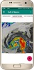
With the app, you can explore NOAA GOES satellite images that support weather forecasting and tracking events like tropical cyclones. These high-quality visuals span areas including the United States, Canada, Mexico, Central America, the Caribbean, and South America. The app updates radar images every 10 minutes, offering the most current weather data. Additionally, you can easily switch between cities to observe cloud positioning across different locations, all accompanied by satellite cloud animations.
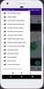
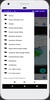
User-Friendly Interface and Download Options
Accessible and intuitive, NOAA Weather Satellite Radar simplifies the process of viewing and downloading your preferred radar or satellite images. A simple click lets you save desired visuals for offline reference. This straightforward functionality makes it an efficient tool for anyone seeking reliable weather information.
NOAA Weather Satellite Radar combines precision with simplicity, making it an excellent choice for monitoring real-time weather developments through detailed radar and satellite imagery.
Requirements (Latest version)
- Android 5.0 or higher required
Comments
There are no opinions about NOAA Weather Satellite Radar yet. Be the first! Comment